
Severe tornadoes, a nor'easter, and a "bomb cyclone" are impacting parts of the country this week.
Funnel clouds, accompanied by strong winds appeared in various parts of Kansas, Illinois and Missouri on Sunday. Thousands are without power. Severe weather is expected to continue over the next two days.
A powerful low-pressure system known as a nor'eastern has been moving toward the east coast and could move up the New England coastline and bring with it heavy rain and flash flood warnings. There is also a risk of tornadoes.
(USATODAY) - A furious storm unleashed from a "bomb cyclone" over the Pacific Ocean slammed ashore Sunday in drought-plagued Northern California and the Pacific Northwest, blasting a wide swath of the West Coast with heavy rain, damaging winds, flooding and mudslides.
Over 160,000 homes and businesses in California, more than 170,000 in Washington, and over 28,000 in Oregon were left without power on Sunday due to the extreme weather. Two people were killed when a tree fell on a vehicle in the greater Seattle area.
Flooding across the San Francisco Bay Area closed streets in Berkeley and inundated the Bay Bridge toll plaza in Oakland. By Sunday morning, Mount Tamalpais, just north of San Francisco, had recorded a half-foot of rainfall during the previous 12 hours, the weather service said.
The National Weather Service in Sacramento warned of "potentially historic" rain for the city's downtown.
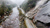
North of the state capitol in Butte County, California's Highway Patrol closed down State Route 70 due to mudslides and debris flows near the now-contained Caldor Fire, which scorched more than 346 square miles of the Sierra Nevada and burned hundreds of homes.
"If you are near a burn scar, it may be too late to evacuate," the weather service in Sacramento said on Twitter. "Do not attempt to cross a debris flow. Take shelter in the highest floor of your home."
Several parts of California, including the Santa Cruz Mountains and parts of western Santa Barbara County, have instated evacuation orders because of their proximity to burn scars.
The storm was forecast to pound some areas with a foot of rain while dumping up to 8 feet of snow over the mountains, forecasters said.
A bomb cyclone forms when air pressure rapidly drops as the storm explosively strengthens. The phenomenon was pulling deep tropical moisture from the Pacific, creating an "atmospheric river," AccuWeather Meteorologist Jon Porter said. He described the river as a "firehose of moisture in the sky" capable of unleashing intense rain and mountain snow.
The storm was most severe in the northern and central portions of California and part of southern Oregon, with the greatest intensity lasting into Monday, he said. Rainfall of up to 2 inches an hour may come "too fast and too furious," leading to serious flooding and mudslides that could threaten lives and property, Porter added.
The National Weather Service Bay Area issued a plethora of flash flood watches, saying on Twitter: "Main concern will be 2020 burn scars but urban and small stream flooding likely as the heavy rain band passes through Sunday afternoon and night."
"Flooding, rock slides, chain controls, overturned vehicles – and that was just this morning," the California Transportation Department tweeted Sunday. "This atmospheric river storm is expected to intensify with heavy rain and significant snow into tomorrow. Do NOT drive if you don't have to."
Parts of Oregon were under siege from strong winds and heavy rains. Pacific Gas & Electric said it had thousands of workers ready to respond to outages.
The region needs the rain. California Gov. Gavin Newsom just last week declared a drought emergency for the entire state, citing three years of drought across the West.
Seventeen major wildfires are burning in California, Idaho, Montana, Oregon and Washington, according to the National Interagency Fire Center. Wildfires have burned almost 2 million acres in California in 2021 alone. The storms will effectively end the wildfire season in much of the region, AccuWeather's Porter said.
"This rainfall is coming about a month ahead of average and will be very welcome in fighting the remaining fires, particularly in Northern California," Porter said.
Snow will begin to fall at elevations above 8,000 feet, but then drop down to elevations around 6,000 feet by Monday, AccuWeather said.
"Given the amount of moisture aiming at the northern and central Sierra Nevada, there can easily be 60-100 inches of snow at levels above 8,000 feet," AccuWeather Senior Storm Warning Meteorologist Rich Putnam said.
 02/19/26 - Cornerstone University Announces New Approach in Education