

Hurricane Ida came ashore less than 100 miles south of New Orleans and thousands are without power.
(USATODAY) - More than 1 million homes and businesses were without power Monday across a swath of Louisiana and Mississippi as Ida, downgraded from a furious Category 4 hurricane to a tropical storm, still pounded the region with heavy rains and storm surge.
Ida, which roared onto the Gulf Coast near Port Fourchon, Louisiana, on Sunday with 150-mph winds, knocked out power to the entire city of New Orleans. On Monday morning the storm was centered over southwestern Mississippi.
Roofs were torn off buildings by the powerful winds, and there were reports of some levees outside parish systems being overtopped. Some neighborhoods were swamped, and residents found 911 unreachable or unable to help amid the carnage.
Winds had decreased to about 60 mph but tropical storm-force winds extended out 150 miles. The storm was inching north at 8 mph, the slow roll driving up rainfall totals along Ida's path.
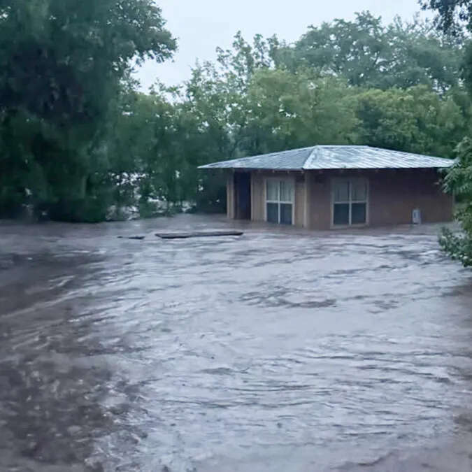
Mayor Tim Kerner said much of the Town of Jean Lafitte, a community of 2,000 people just outside Jefferson Parish levee protection system, was underwater. Kerner told WGNO the levees were overtopped by rapidly rising water. Parish President Cynthia Lee Sheng told the station that "people are in attics in Lower Lafitte."
"Total devastation, catastrophic" Kerner said. "This is a very dangerous situation. I’ve never seen so much water in my life. We’ve lost our school and everything ... People’s lives are I believe at stake now.
Through Tuesday morning, Ida could bring total rainfall accumulations of 10 to 18 inches with isolated maximum amounts of 24 inches, the weather service said. Heavy rain combined with storm surge has resulted in catastrophic impacts along the southeast coast of Louisiana with life-threatening flash flooding and "significant" river flooding continuing farther inland.
The center of Ida is forecast to move over central and northeastern Mississippi on Monday this afternoon and night and move across the Tennessee Valley on Tuesday. Additional rapid weakening is forecast during the next day or so, and Ida is expected to become a tropical depression by Monday evening. "Considerable" flash flooding is possible from the Lower Mississippi Valley through the Middle Tennessee Valley, Ohio Valley, Central/Southern Appalachians and into the Mid-Atlantic in coming days, the weather service says.
Some 30,000 crews are standing by to help restore power but they will be delayed due to flooding.
 07/07/25 - Relief Agencies Work to Provide Disaster Relief
 07/01/20225 - Festivals, Parades, and Fireworks are scheduled this week to celebrate independence.
 06/30/25 - Kent County Man Drowns in Wabassis Lake; Sheriffs Remind Residents of Boating Safety
 03/25/25 - Habitat Kent County Plans Major Housing Project